Jotunheimen – Giants and fields of rocks
(This is part 3 of the MASSIV series. If you haven’t read part 1 and 2 yet and you like your stories in chronological order, I recommend checking those out first.)
Day 4: Sognefjellshytta – Fannaråkhytta
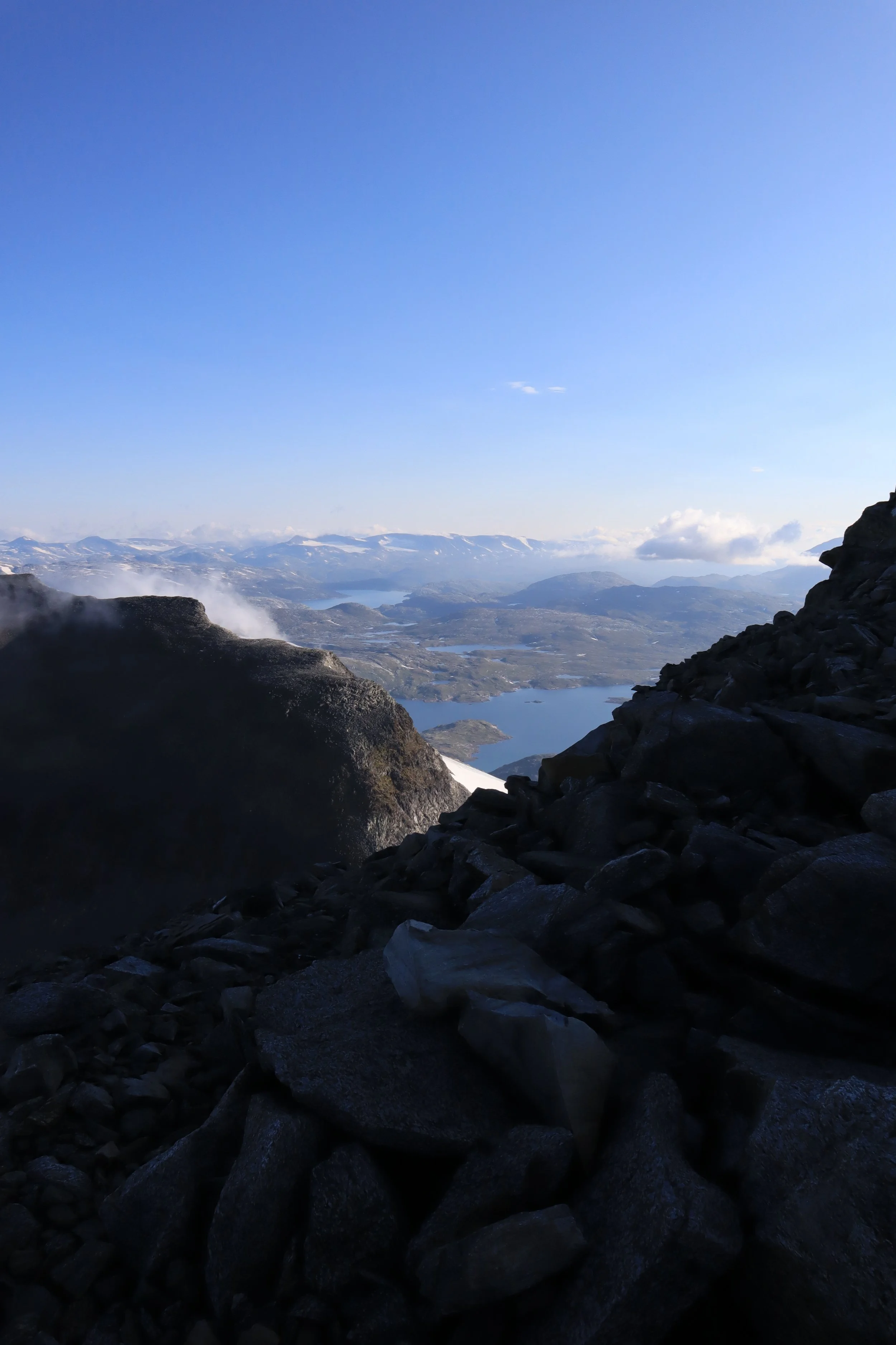
After two exhaustingly long days, both in terms of kilometres hiked and time spent hiking, it was a delight waking up and knowing that we would only be hiking 16 km that day. Even if it was going to be a short day we were up early and out the door straight after breakfast to make sure we would make it to the edge of the glacier in time to meet up with our guides. To get to the top of Fannaråken from Sognefjellshytta you need to cross Fannaråkbreen (The Fannaråk glacier). The staff at Fannaråkhytta provides guides for the crossing every day during the summer season, but you have to book a spot in advance. On clear days you can see the top of Fannaråken from Sognefjellshytta, but as we left the cabin we could only see the base of the mountain and the glacier as the rest was covered by clouds and fog.

The day started in relatively flat terrain, which was a joy, especially compared to the ups and downs of the previous day. The hike to the edge of the glacier was relatively uneventful, and when we reached the meeting point we realised we had made really good time on the way in and had an entire hour to spare before the glacier guides were going to show up. While we waited we put on some extra layers of clothes, found a nice rock shelf to sit on and ate some of our lunch. After about half an hour we were joined by a man who turned out to be one of the men that had been tenting outside Nørdstedalseter. The rest of his buddies had decided to go straight from Sognefjellshytta to Skogadalsbøen, but he figured that since he was already here, he might as well take a detour and go up Fannaråken on the way and then join back up with them at Skogadalsbøen for dinner.


When the guides arrived, we put on harnesses and crampons and tied into a rope before we started walking. While the glacier hike two days earlier had mostly felt like transport (even if it was really cool), this one on the other hand was an experience. The guides stopped in a couple off different places to give us time to look at the view and point out in which directions we would have seen the different mountains it they weren’t obscured by the clouds. As well as to point out things like holes made by melt water, why the glacier is red in some places and the many dead lemmings. After having reached the other side of the glacier we parted ways with the guides and our new buddy, all of whom practically ran the rest of the way to the top of the mountain. The guides so that they would make it up in time to start helping with dinner prep and our new friend so that he would make it up and back down in time for dinner at Skogadalsbøen.
We on the other hand decided to let the crazy fit people have their running to themselves and chose the more moderate pace called walking. When crossing the glacier we had stayed mostly under the clouds but as we once again reached solid ground we also stepped in to the clouds and fog. As we slowly made our way to the top, we rediscovered why we like trails with well-made cairns when the weather decides not to be on your side. The fog was quite thick the rest of the way up, and most of the time we could see the next three, maybe four, cairns ahead of us but not much more. Walking straight up into an endless white nothing like that is kind of demotivating as you can’t see if you are getting any closer to where you are going, and you also can’t see the how much distance you have put behind you. At this point my feet were getting quite sore from walking on stone, so when I suddenly saw the vague outline of something that could be a building in front of me and realised that we probably had less than 70-60 meters left before we were at the cabin I was relieved.

Photo: Yngvild H. Castle
When staying at Fannaråkhytta you sleep in the building that was once used as a weather observation post. Dinner and other social activities are done in the “new” DNT cabin which is situated a short distance away, and a little ways of at nearly equal distance to both cabins is the outhouse. It is not the fanciest nor the prettiest outhouse you’ll ever visit, but it could probably win the price for Norwegian outhouse with the most updraft. (For any men planning a trip to Fannaråken, the warning sign is not a joke even if the fun drawing might make it seem like it is. Please sit.) Fannaråkhytta is a relatively small cabin with only 34 beds, and on days when the weather is good they sometimes cram people onto every and any flat surface, both inside and outside, to make room for everyone who wants to stay overnight. When we visited on the other hand the maximum number of people that was allowed to stay overnight was set to 14 due to covid restrictions.
After having checked in and been assigned a bunkbed in the corner of the sleeping hall, we made our way back to the common room where we read some books until it was time for dinner. They do, impressively enough, serve a three-course meal at Fannaråken. But unlike at the other DNT cabins it is made entirely of canned and dried foods, which means that the starter is some kind of soup, in this instance it was cauliflower soup. The main course is always Joika, and the dessert is either canned pears or apricots. We got pears, which I was really happy about as I am not particularly fond of neither apricots nor Joika. After dinner we played a few card games and then something unexpected happened.

It turned out it was one of the other guests birthday, and some of the staff had taken this as an excellent excuse to have a baking contest. They had made two cakes and all of us guests were invited to try them and join in on the judging. If I remember correctly the chocolate cake won. We had gotten a few short glimpses of the mountains that were hiding in the fog before dinner, but when we walked back to the other cabin to go to bed the fog was once again thick and we got to appreciate the impressive number of cairns that marked the way between the cabins, and also the outhouse. But even with the well-marked paths I was crossing my finger that I wouldn’t wake up and have to go to the outhouse during the night.
Day 5: Fannaråkhytta – Skogadalsbøen

Photo: Yngvild H. Castle
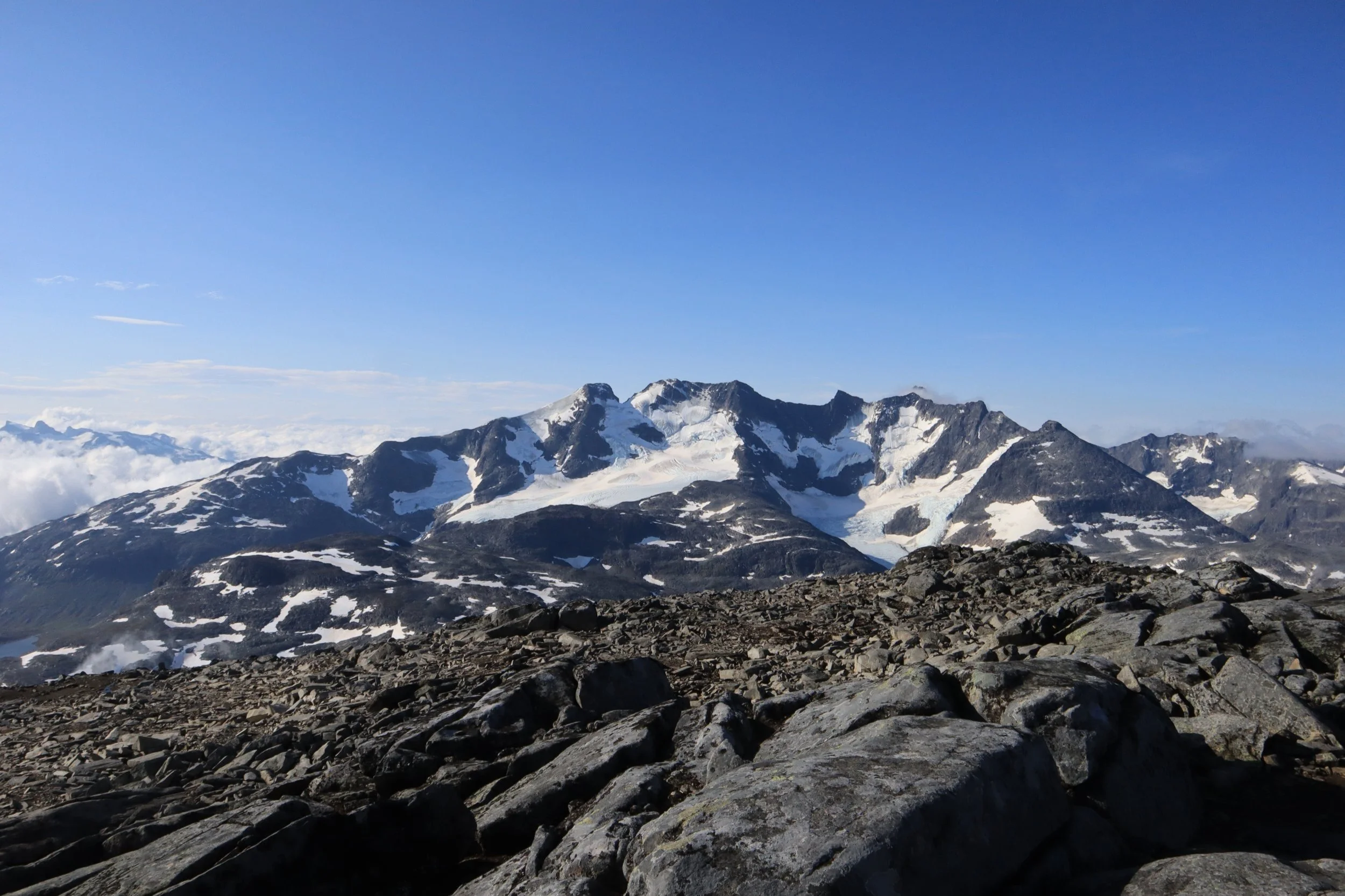
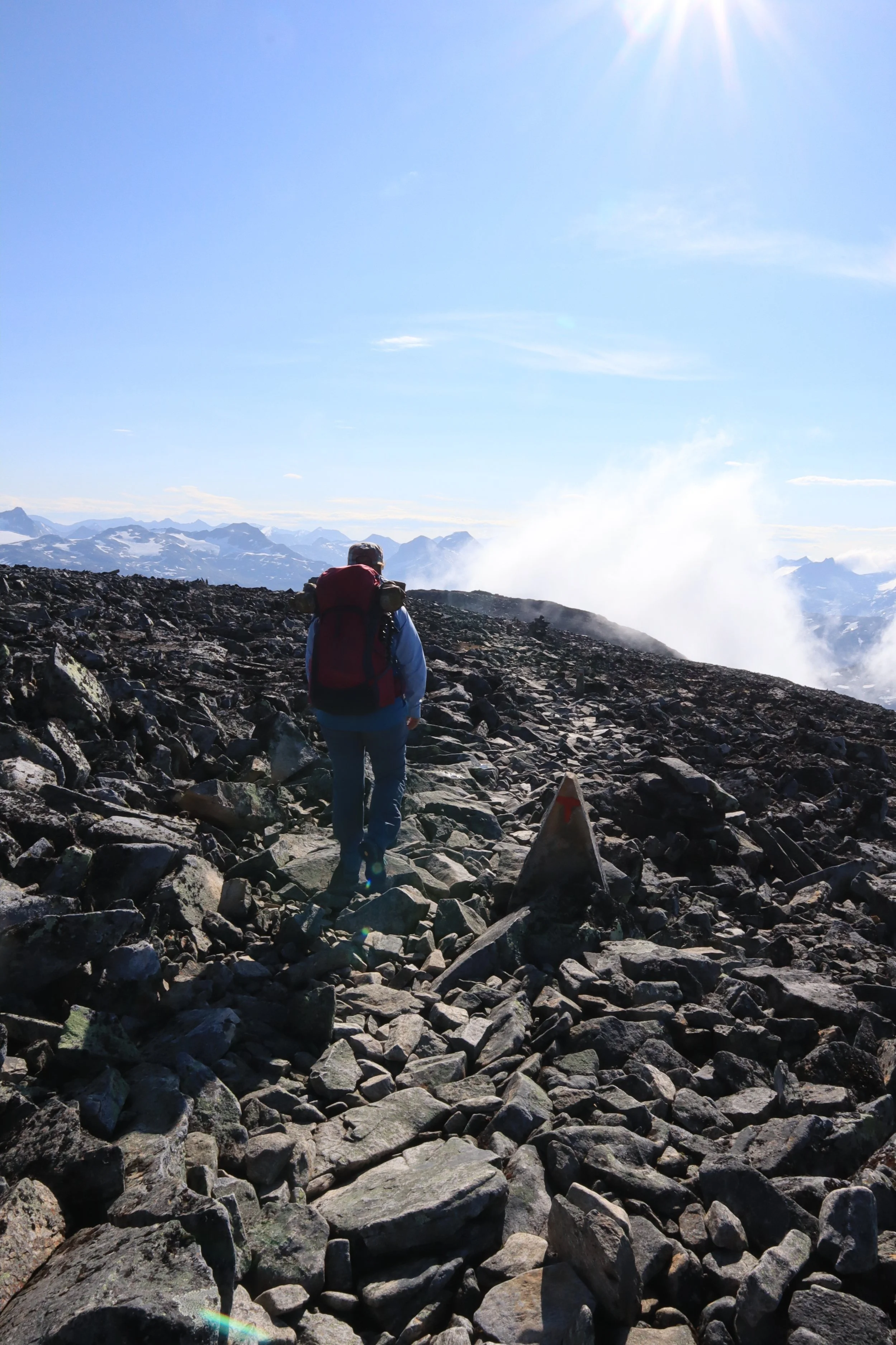
When we woke up the next morning the fog was still obscuring the view, but we were hopeful that it would clear up before we needed to head out because the forecast was predicting sunshine. We packed our backpacks before breakfast and while we were eating the sun poked out from behind the clouds and just like the curtains of a stage part to reveal the set behind them, the fog lifted to reveal the most stunning 360 degree view I have ever seen. Hurrungane in one direction, Smørstabbtindane in another, and right in front of us as we went out the door, Skagarstølstindane. It is the kind of view that leaves you speechless and makes you appreciate why this part of the country is called “home of the giants” (Jotunheimen) Both of us were just walking around smiling like two idiots, taking lots of pictures, and fully soaking it in.


We could have probably spent all day taking in that view, but alas we had to start walking. The hike down to Skogadalsbøen was relatively easy with downhill slopes most of the day. The first part was a bit steep and hard on the feet and knees, but the further down towards the valley we got the smoother the slopes got, and the ground shifted from stone to sand, grass and dirt. After three consecutive days of mostly stone and scree that was a welcome change. With the lower elevation also came more vegetation, and when we stopped for a pee break, we discovered that the entire area near where we had stopped was covered in ripe cloudberries. This was a nice surprise, and seeing as you can’t let an opportunity to have some cloudberries go to waste, the pee break turned in to a pee and cloudberry break. The cloudberries were deliciously juicy and sweet, and felt like a proper luxury. After having eaten quite a few handfuls of them we continued on with renewed energy. We had been able to see Skogadalsbøen for a while, and now we were nearing the bottom of the valley where we would be crossing the river and turning to walk alongside the valley instead of across it. When we got to the bottom of the valley, we were under the treeline for the first time since starting at Sota Sæter, and it was also the first time since leaving home that I started noticing my pollen allergies. When we reached Skogadalsbøen both my nose and eyes were itching and running like crazy. Thankfully an extra allergy tablet calmed it down enough that I wasn’t constantly blowing my nose anymore.


Skogadalsbøen is one of the older cabins in Jotunheimen, and the rooms reflect that in a positive way. The beds are made of beautiful wood and in the single and double rooms we could also see a little desk and chair in the same style. The sleeping hall where we were staying was divided into three sections with two bunkbeds in each of them. The beds had a shelf and hooks for hanging clothes at the foot of the beds and a long shelf under the window between the lower beds. We had scheduled a rest day here so after having been assigned beds and taking a shower we washed some of our clothes that we had been hiking in the last four days and hung them to dry in the drying room. Out of the cabins we had stayed at so far this was by far the one with most people, and when it came time for dinner there was a huge queue in front of the door to the dining hall. That evening we also got a short flute concert during dinner.
Day 6: Skogadalsbøen


For our rest day we didn’t really do much except, well, rest. The day before we had both picked up a book from the “mountain library”. Which is basically just a shelf of books in the common room. So, most of the day was spent reading in different locations around the cabin. After breakfast we went up to the stream and lay in the grass there reading, until it got a little cold and we went back to the cabin to change from shorts to trousers. After that we took a short walk around the area, looking at the different buildings, enjoying the sunshine and checking on our clothes in the drying room. For lunch we ate the food we packed at breakfast in addition to one of Skogadalsbøens famous cinnamon buns. Then we sat outside, read some more and talked to some people that were passing by. And before we new it, it was dinner time. After dinner we, once again, read some more and then went to bed well rested and ready for a new day of walking the next morning.
Day 7: Skogadalsbøen – Fondsbu
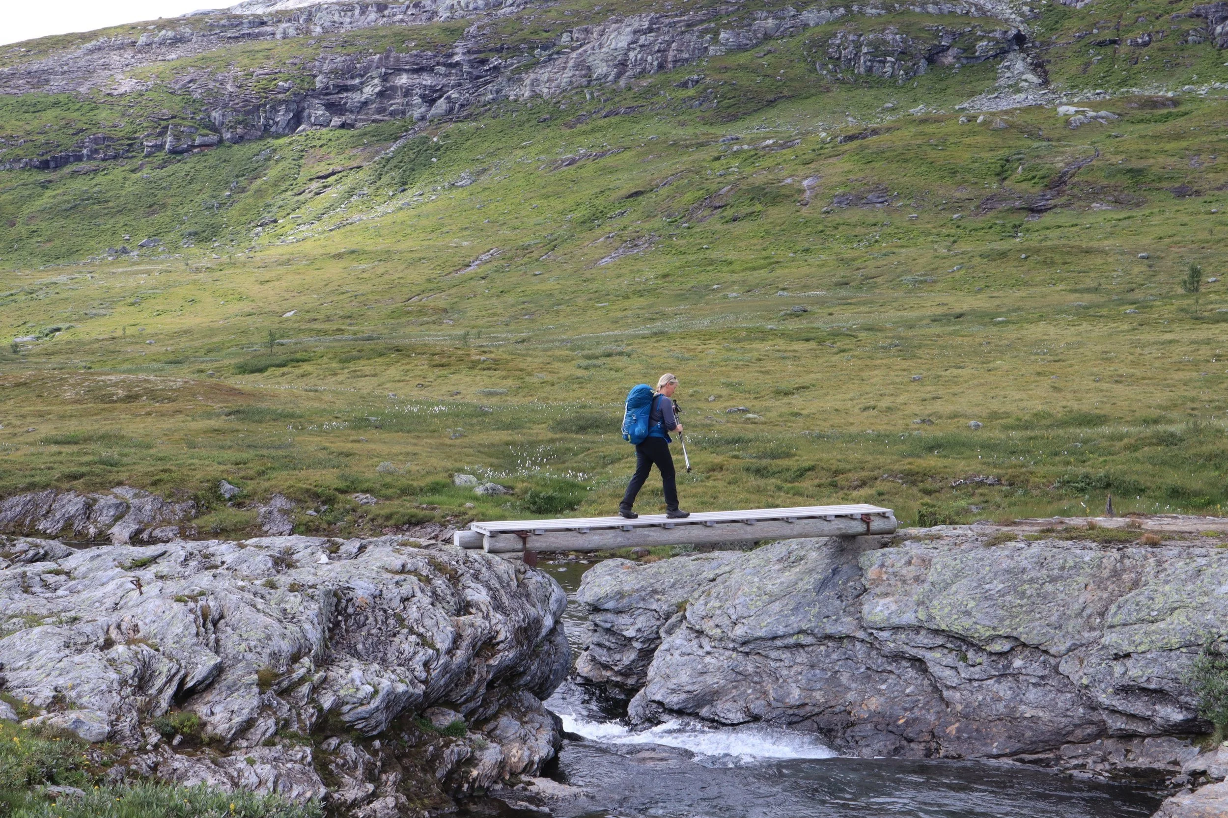
From Skogadalsbøen we followed the trail through Uradalen. For those of you who understand Norwegian, Uradalen is exactly what it sounds like it is a valley filled with scree (Ur- scree, dalen – valley). For the first hour or two of the day we did not see why this valley had gotten its name, because the part closest to Skogadalsbøen is in fact quite green and lush. There was a short section at the start with huge boulders, but then it turned in to a beautiful soft green valley. This continued until we reached the top of the next hill, and from there it was rocks and hard ground for most of the rest of the day. When we reached Uradalsvatnet we sat down for lunch, and shortly after we sat down a small head popped up from the rocks a few meters away form us. It turned out to be a curious stoat, that ended up hanging around for the entirety of our lunch. Jumping in and out from under the rocks, getting up close and running away again.


After lunch we continued walking along the water, jumping from stone to stone, trying to keep up the pace so that we would not have a repeat of day one and two. For most of the day we were looking at Uranostinden, but it wasn’t until we reached Kvitevatnet and turned around to look back that we were able to truly appreciate how cool looking of a mountain Uranostinden is. It kind of looks like the quintessential mountain with a nice flowy ridge and a pointy top. It is also very photogenic and just to top it all of it has a glacier. What more could you want out of a mountain.

From the end of Kvitevatnet until we got down to the road near Fondsbu the trail started being a little hard to find. All of DNTs paths are marked with red Ts on rocks and cairns. The rules on how to mark a trail is rigorous enough that you have to take a specific course to be allowed to do it, and they have an entire book on the proper ways to do it. However, there are around 20.000 km of trails marked by DNT in this country, so sometimes you will hit sections of trail that haven’t been upkept in a while. And when that part of the trail is in a literal sea of rocks and you are looking for a tiny red T that is on a rock, and that rock might have fallen over or the paint faded with time they end up being quite hard to find. This is one of the many reasons why you should always bring a map even if you are going to follow a well-established route. Whenever we were not able to see the path or weren’t able to see any red Ts we checked the map to make sure we were still going in the right direction, or even looking in the right direction to find the next T. And adjusted our heading if needed and then usually found the next T shortly after.
Having spent a lot of extra time trying to not loose the path, we ended up making it in the door right as the 7 o’clock dinner was about to start. We had seriously power walked the last two – three kilometres in an attempt to make it in time for dinner at 7, but as we got there a tad bit late, we had resigned ourselves to having to wait until the next seating at 9 o’clock. But as we sat down on the bench in the hallway to take of our shoes a very lively woman came out to us wondering if we were going to have dinner. To which we, mildly confused, answered “yes?!?”. And she joyfully proclaimed “Super, just leave your backpacks here and follow me to the dining hall, and then we will check you in after dinner.” Turned out she was the host of the cabin and that she had come by the hallway to check if there were any late arrivals that would like to have dinner right away in stead of waiting for the next seating.

Photo: Yngvild H. Castle
Having come in the door and then being seated for dinner right away, we felt a little “under dressed” even for a DNT cabin. It had been a long and sweaty day and the last hill down towards the cabin had been quite muddy, so we were not exactly clean. Especially compared to the rest of the people there who had clearly had the time to get a shower before their meal. The dinner was lovely, even though the dessert (brown cheese parfait) was a little weird. I have also noted in my hiking log that we got green pea soup as the starter, which was a welcome change from all the white soups we had gotten thus far. And in usual Fondsbu fashion the host preformed a kved (traditional song) before dessert.
It seemed we had used up our luck for the day by getting dinner straight away, because when we were checking in after dinner, we learned that the showers closed at seven due to how the cleaning schedule was set up. However, we were allowed to use them if the indicators on the door were turned to green. They were not. We had looked forward to this shower as we were going to stay at self service cabins for the next four days, which meant that this was the last proper shower in a while. But since they were closed, we did not get to take a shower after all. Instead, Mum opted for a wash in the sink, and I ended up with a reluctant and freezing cold bath in Bygdin. Which was not enjoyable in any way or form, but at least I got clean. Later that evening we ran into one of the women we had talked to during our rest day at Skogadalsbøen, who had unfortunately had to stop her hike and was preparing to travel home the following day due to her mother being sick.
Day 8: Fondsbu – Slettningsbu

This was the day for road walking. We started of with a long stretch on gravel roads. The upside to this being that we made good time, the downside being that it was hard on our already slightly sore feet. After the huge amount of scree the day before, and starting the day with roadwalking we were delighted to find that when we finally got of the gravel road the path had loads of both mud and bogs, which is soft to walk on. It did however end up being a bit too much of the good stuff as we were approaching Tyinoset. Here the nogs were extremely wet, which resulted in my shoes being completely drenched. But even with wet feet the mood was high as the weather was just warm enough that we had folded up the legs of our trouser and we did not need to put on our down jackets for the second lunch break.
After having eaten the last of our lunch we once again hit a section of road walking. This time with both gravel and tarmac. The tarmac was particularly hard on the feet, and when we got back into the terrain my feet were aching. The last leg of the day was a long and steep hill, but with a few short breaks to catch our breath and drink some water the hill was conquered surprisingly quickly. From the top of the hill we cloud see the cabin in the distance, and the last kilometre or so went by quickly. When we got to the cabin we wrote ourselves in to the protocol and chose a room. Then we cleaned of in the freezing cold pond and made canned stew for dinner. There was one other man staying at the cabin with us, and a father and son with their two dogs stayed in the other cabin.


The next day we would be staring the third section of the adventure, Skarvheimen. See you in the next one 😉

Photo: Yngvild H. Castle