Skarvheimen – Entering reindeer country
(This is part 4 of the MASSIV series. If you haven’t read the previous parts yet and you like your stories in chronological order, I recommend checking those out first.)
Day 9: Slettnigsbu – Sulebu

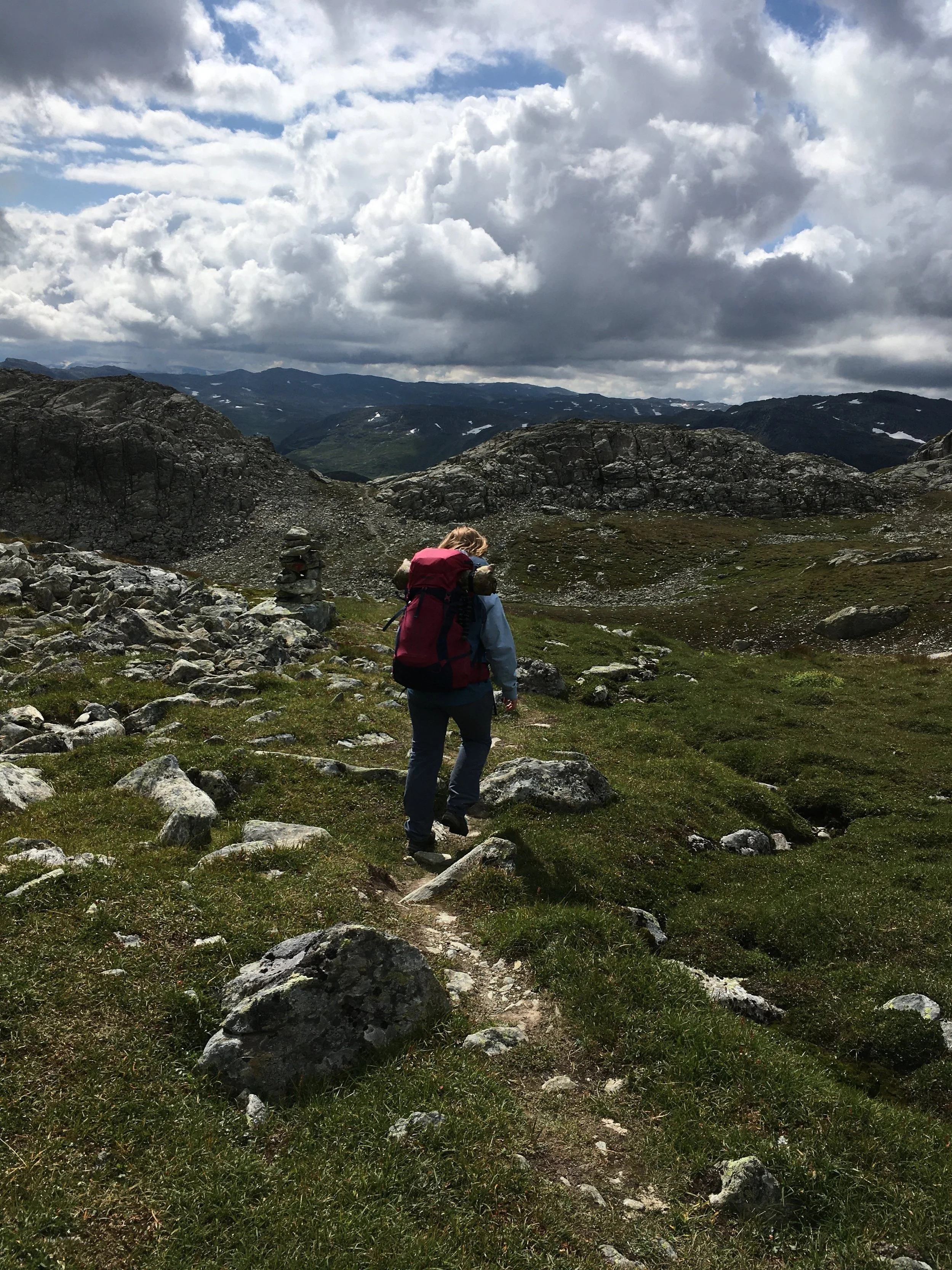
For our first day in Skarvheimen we got a relatively easy hike. The first part of the day the trail snaked its way passed several smaller lakes in terrain without too much elevation difference before steeply descending to Kyrkjestøylen where we stopped for a quick call home. After leaving Kyrkjestøylen the trail follows the King’s Road over Filefjell for about a kilometre before it departs form the road and follows a different trail. Being back on the King’s Road felt kind of weird. A few years back we hiked that road in pouring rain and didn’t really thing we would be back. We even ended up passing our old campsite, this time in nice sunny weather, and concluded that it was still the only spot along this section of the road where it was possible to pitch a tent.
After the first bend in the road I noticed a wooden reindeer overlooking the area and pointed this out to Mum by saying: “Hey look, a reindeer!”. She was a bit disappointed when she realised I was not referring to a real reindeer, but agreed that it was indeed a cool looking reindeer. About 200 meters later however we heard some sounds in the woods to our left and suddenly an actual reindeer jumped out into the road right in front of us, stopped for a moment, and then ran of into the woods on the other side of the road. To say we were surprised is an understatement. And to be honest the reindeer looked a little surprised as well. After collecting ourselves from the surprise we continued up the road, passed our old campsite and turned onto the trail towards Sulebu. The trail started by going straight up through the birch forest before breaching the treeline and continuing up a little longer before flattening out into beautiful flat-ish terrain.


It was a clear day and looking back we could see Skagastølstindane and Fannaråken far of in the distance. Looking at them knowing we had walked all the way from where they were, and then some, felt strange. It wasn’t that many days ago that we were on the top of Fannaråken and already it was so far away. It felt surreal to have walked that distance. At the same time I felt a strange sort of pride. We had after all walked from behind those mountains, that looked tiny on the distant horizon, to where we were now standing. Amazing!
Letting this realisation continue to spin around in our minds we continued towards the cabin. On the way we passed no less than 15 more reindeer. Having never seen a reindeer in real life before, I would say seeing 16 in one day is pretty cool :D
After reaching the cabin we took a quick dip in one of the lakes (for those wondering, yes it was just as freezing as the two previous days). Made some pasta for dinner and spent the rest of the evening hanging out and talking with the other people that were also staying at the cabin. One of them was trying to hike across Norway on the widest part. Seeing as the shape of Norway looks kind of like a tadpole or a spoon, depending on which description you find to be the most fun. There are several substantially shorter hikes you can take to get from the border with Sweden to the sea. Up by Narvik you can do it in a day, and in Trøndelag there is a hike that is called “Norge på tvers” (Norway across), that takes about a week. So deciding to find the point where the country is the absolute widest and hike across at that point is quite impressive.

Day 10: Sulebu – Skarvheim

Photo: Yngvild H. Castle
The day started with the same flat-ish terrain as the day before, going past Øvre Sulevatnet and then up a pass between Suletinden and Sulefjellet. At the top of the pass we took a short snack break, and while we were sitting there looking up at Suletinden Mum remarked that the bushes in the middle of the big snow patch looked almost like reindeer. And I agreed. Then we looked at them some more, and after a while some of them started moving and we burst out laughing as we realised that the “bushes” that almost looked like reindeer were in fact not bushes at all. They were reindeer.

After having come down the other side of the pass, most of the rest of the days hike continued in lush green, flat terrain with a slight downhill slope. The next couple of kilometres after the pass were so flat it felt like hiking on a highway, if highways were made of soft grass. This was especially welcome since my feet still had not recovered completely from the roadwalking two days earlier. And in addition to sore feet, I also wasn’t feeling too good in general due to a massive tummy ache. I blame the porridge I had been eating for breakfast the last two days. If you are ever going to eat the portion sized instant porridge packets that they have at the self-service cabins, for the love of all that is holy and, you know, general hiking happiness. Make sure you put enough water on that shit before you eat it, or you will regret it.


For the last section of the day we had a steep decent down to the cabin. If my feet were not aching before that last kilometre and a half absolutely killed them. On the upside, when we got to the cabin we found out that the rumours were true and the cabin did in fact have a proper shower, with hot water! Having done so much planning for this journey, we had done extremely little research about the different cabins other than figuring out if they were staffed or self-service. So getting to a self-service cabin with a shower was an extremely pleasant surprise.
Day 11: Skarvheim - Bjordalsbu
The warm shower and a good night’s sleep had done a lot to help with the sore feet and had restored most of the energy drained by the porridge related problems. Combined with the knowledge that the upcoming hike was only going to be 13 kilometres it was looking to be a fantastic day. Plan of attack: Get an early ish start, hopefully get to the cabin early and then have a long relaxing evening. The hopefully being added after looking at the map and seeing that the entire day would be uphill. With that in mind we set of to conquer the first hill.
Apart from being uphill the first part of the hike was lovely, with lots of nice grassy ground and pretty views. A way past the first long hill we met a man that had taken a nap outside the Skarvheim cabin the day before. After leaving the cabin he had hiked on to where we met him and slept under a tarp. When we came past, he was drinking his morning coffee whilst trying to figure out if the trail was going over or between the peaks ahead but was having trouble due to the scale of his map. Our map was in a more detailed scale, so we let him have a look at that. And since we were going in the same direction, we all agreed that according to the map the trail was in the valley between the peaks. We then left him to finish his coffee and continued on a little further, too about the halfway mark of the day, before we stopped for lunch.

Photo: Yngvild H. Castle
Lunch consisted of my least favourite kind of bread, crisp bread, with liver pâte. I do not understand people who like eating something that ends up having you be tiered of chewing long before you are even remotely full. Anyways… let’s get on with the story. After having finished our dry, crispy, boring to chew lunch we continued going uphill and the terrain changed from green grass to grey rocks and scree. The last kilometre felt endless. The wind had picked up substantially and the cabin was nowhere in sight. Just a seemingly endless expanse of rocks in front of us. And then as we crested a hill we were there. Two small cabins and an outhouse next to a lake in the middle of a sea of rocks. The wind was not letting up, and had the gusts were still increasing in force. So after having spent half a moment taking in the surroundings we quickly got inside. But only after having taken note of the sign outside the door telling us to make sure to close the door properly due to wolverines. Not wanting to meet one of those in the entrance we did as the sign told us to and made doubly sure the door was closed before heading into the hallway and writing ourselves in to the protocol and finding a room.

The cabin didn’t look like much from the outside, but on the inside it was surprisingly spacious with a practical layout, high roofs and soooooo many pegs to hang things on. Looking around I struggled to find anywhere it would be possible to mount any more. Which is impressive. At this point we had been staying at several DNT cabins and one of the things we were missing at most of them were adequate space to hang up wet clothes. At Bjordalsbu this was not a problem. Literally the entire length of the wall above my bed was filled with pegs. A+ design choice. You can never have to many places to hang things in a cabin.

Day 12: Bjordalsbu – Iungdalshytta
The hike from Bjordalsbu to Iungdalshytta, terrain wise, was the opposite of the hike the day before. The first part of the day was mostly rocks and scree while the second part of the hike was grassy and green. It was also, at least for the second half, mostly downhill. Even if the wind had died down quite a bit over the night it was still a windy day. And after two days of not feeling all there, I was finally back in the game. I think we both felt well rested after the long afternoon and evening at the cabin the day before, and my feet had finally gotten enough rest to be ready for taking on some longer days again.

We set of from the cabin in good spirits, ready to take on the sea of rocks in front of us. Soon after we started, we hit the first obstacle of the day. Two long and steep areas of snow. The snow slowed us down a little as it was covering a lot of the cairns and res Ts, but between consulting the map and the few Ts we eventually found we made it past the snow without difficulty. After that it was smooth sailing, or you know hiking 😉.
For the first lunch of the day, we found a perfectly shaped rock to sit behind that gave us just enough cover to get somewhat out of the wind. So we hunkered down and ate some of our lovely crisp bread, and then continued walking before we got too cold. After we left the rocks behind and started getting down into more vegetated areas we started picking up more speed, and the sun even decided to peek out behind the clouds for a while. By Store Klevavatnet we made the decision to stop for a second lunch. Even if we didn’t have all that far left to go, we were starting to feel out of energy, and we knew we were making good time and would have more than enough time to spare before dinner at Iungdalshytta. While we were sitting down looking at the view over the water the waves were getting bigger and were starting to get white tips. The clouds on the horizon were turning darker as well. We knew the forecast was predicting rain in the evening, so instead of waiting around for it we quickly packed our puffer jackets beck in our bags and decided to see if we could beat the rain to the cabin.

I am not lying when I say I have never seen Mum hike that fast ever before. And downhill at that (which usually goes substantially slower than uphill or flat sections, especially late in the day). It felt like we were flying down the hills. In all honesty I did not expect her to put in that sort of gearchange, but in fear of her slowing down again I said nothing and just did my best to keep up. Miraculously we made it inside before the rain, and as we were taking our shoes of I told Mum I was thoroughly impressed by the pace she had set, and she admitted she was a little impressed herself as well.
Dinner that night was probably Mums favourite on the entire hike, simply because they served sour cream porridge as a starter. It is Mums favourite meal, and a typical traditional dish that you could expect to get at a DNT cabin, and she was starting to worry that she was going to spend three weeks in the mountains without getting any. I on the other hand am not a big fan of sour cream porridge, so I was happy to find that the rest of the dinner was more to my taste. Even so I must admit that it was the best sour cream porridge I have eaten.

Day 13: Iungdalshytta – Geiterygghytta
After having been out for nearly 13 hours on the 25 kilometre hike to Sognefjellshytta, we did not have high hopes of reaching dinner at Geiterygghytta seeing as the hike from Iungdalshytta to Geiterygghytta is 29 kilometres. This was the longest day, distance wise, on the entire MASSIVE route and judging by the time we had spent on the previous long days we were preparing for a potentially extremely long and tiering day.

Photo: Yngvild H. Castle
The weather was not exactly pleasant, storm strength wind with predicted rain throughout the day. This however turned out to be a good thing. This kind of weather is not conducive to long breaks or any sort of sauntering pace, in fact it encourages exactly the opposite. Minimal, short breaks and keeping a pace that will ensure you will be out of the wind, rain and cold sooner rather than later.
For the first two thirds of the way we had the wind at our backs, which was fortunate as it is a lot easier to hike with storm strength winds than against them. It also means your face is going to be mostly dry when its raining, which is endlessly more pleasant than having a constant spray of rain hitting your face all day long. It is also warmer than walking against the wind as your backpack shields most of your body from the wind, and as an added bonus the wind sort of pushes you along instead of working against you.
The most exiting part of this hike must have been almost falling in a river. We were crossing a wide, but not too deep river. There were lots of rocks in the river so it should have been easy to cross if it hadn’t been for the wind. We were standing in the middle of the river. I was leaning against the wind in order to keep upright (yes, that is how strong the wind was), one of my mum’s trekking poles in one hand, holding out my other hand to help Mum go from one rock to another and then, the wind let up for half a moment. If it hadn’t been for the fact that I had put the trekking pole out in the direction I was leaning to keep upright in the wind I would have fallen face first into the river. Thank you trekking pole for saving me from getting completely soaked.
We stopped for a proper lunch break outside Kongshelleren where we once again met the “tarp” man we first encountered at Skarvheim and a girl we had dinner together with the day before, and had a little chat before they started to get ready to move along. While we were finishing up our lunch the guy walking the width of Norway and his dad caught up to us. The dad had slipped on a rock and twisted his ancle. They were also going to Geiterygghytta but were now planning to take a few hours to rest at Kongshelleren and then see if they would be able to continue or would have to stay the night. (They did end up making it to Geiterygghytta about an hour after us)
After having seen them safely inside we continued walking. From Kongshelleren the trail shifts direction and we were now being hit by the wind from the side. We were determined to get to Geiterygghytta as quickly as possible, because we were starting to get tiered and were really looking forward to a warm dinner. After a quick stop to tape up some blisters and a few painful kilometres later due to extremely sore feet we finally saw the power lines. Now, usually powerlines aren’t on my list of things I want to see on a hike, but for this particular hike I have never been happier to see powerlines in my life. We had been at Geiterygghytta a few years earlier and new that those powerlines went straight past the cabin and that the trail crossed beneath them about 1 kilometre away from the cabin. Which in turn meant that we were now nearly there.
After having started from Iungdalshytta at 08:30 we arrived at Geiterygghytta at 18:00. An entire hour before dinner. To say we were impressed with ourselves is an understatement.

Day 14: Geiterygghytta
After the 29 kilometre day it felt fantastic to have a rest day. Most of the day was spent reading and resting, as well as checking up on the things we had put in the drying room. We also took some time to explore outside the cabin and get some fresh air while the sun was out. And Mum took many pictures of the chickens.


Day 15: Geiterygghytta – Finsehytta
Having done our utmost to do practically nothing the day before we were now well rested and ready to start on the last leg of the journey. In a week we would hopefully be at Haukeliseter having put 350 kilometres of trail behind us. But before that we had 7 more days of hiking left.
The hike to Finsehytta felt nice and cozy. The terrain was easy to walk in even though it was mostly rocks, but unlike the rocks we had encountered before these were mostly small and flat which made the trail feel almost flat. At least compared to everything else we had encountered so far. The day started by hiking the length of Geiteryggvatnet before an elevation change up towards Klemsbu. On the top of the pass under the mountain Sankt Pål we got our first glimpses of Hardangerjøkulen. Seeing the massive glacier peeking out from under the low hanging clouds was one of my favourite moments from the entire hike. It felt like it was beckoning us towards it, welcoming us to Hardangervidda and the last leg of our journey. I could not stop smiling all the rest of the way down to Finse.


The dormitory at Finsehytta was the least impressive or cozy room we stayed in on the entire route. The cabin was newly refurbished, but the dormitory we ended up in was on the loft of the older part of the cabin with four double beds. One in each corner, a few hooks to hang stuff on and a massive metal fire door on either end of the room. Good thing we were not spending our rest day here. On the other hand, the view from the common room towards Hardangerjøkulen was exceptional.
The next day we started on the last leg of the journey: Hardangervidda. But that will have to wait until next time.

Photo: Yngvild H. Castle