My favourite hiking area
The one hike I have hiked the most times in my life is what my family calls hiking around Kringsjå. This is an approximately 5km hike from Steinsfossen in Vennesla, up Tømmerrenna to Kringsjå, over the old dam and back to Steinsfossen following the gravel road to Kvernhusdalen and from there the paved road back to the starting point (or the other way around depending on the mood of the day). Although this is the round I walk most often there are many other options for hikes with Tømmerrenna as the starting point. This is by no means an extensive list, but here you will find some of the more noteworthy destinations that lie in close proximity to Tømmerrenna.
Tømmerrenna is a log flume that was built between 1952 and 1957 and was in use until 1976 or 1977.[1] The log flume is 4km long and was used for floating timber from Beihølen past a section of the river where the water levels weren’t high enough for the timber to pass after the building of the new power plant at Steinsfossen. When the log flume was taken out of use the plan was to demolish it, but instead a foundation was created to take care of it and today they own the log flume and get public subsidy to maintain it.[2]
Most people who come to hike in Tømmerrenna, at least those who aren’t too familiar with the area, go up it and then back down the same way they came. Not that there is anything wrong with that, it is a beautiful hike, but there are so many other interesting things to see in the area. So here are a few of them.
Tømmerrenna to Beihølen
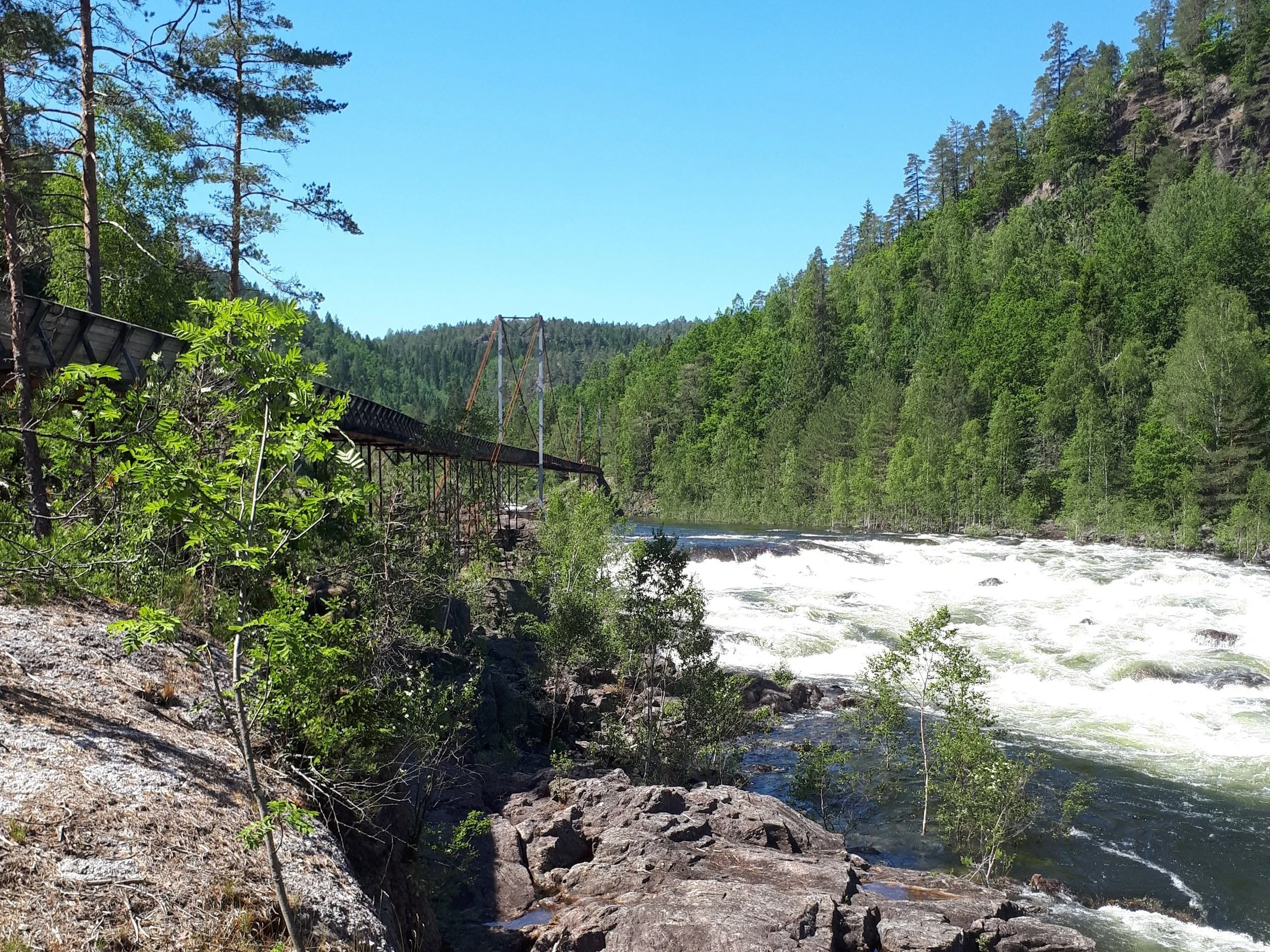
Starting at Steinsfossen Tømmerrenna follows parallel with the river Otra at the left and Setesdalsbanen at the right. Setesdalsbanen ran between Kristiansand and Byglandsfjord from 1896 to 1962, and has been operated as museum railroad since 1964.[3] After 700m the railroad crosses over Tømmerrenna and continues on the other side of the river. A couple hundred meters later Tømmerrenna also crosses the river on a spectacular suspension bridge. After the bridge the flume goes through a tiny tunnel before it continues with a longer stretch through the forest. As it crosses the dam at Kringsjå it once again runs alongside the railroad for a short while until they split off from each other as Tømmerrenna once again crosses the river on a suspension bridge while the railroad continues on the left side of the river. Shortly after the bridge there is a bench called Balkongen (the balcony) where you have a great view of the river, the bridge and Vrengen which is one of the sharpest curves on Setesdalsbanen. 200m after the bridge the flume enters a 100m tunnel. The ceiling is low and the height varies throughout so you will have to crouch down a bit to get through. It is also dark in the tunnel so I would recommend bringing a flashlight. On the other side of the tunnel you enter a narrow valley with the river at the bottom and Tømmerrenna and Setesdalsbanen at either side. The section of the railroad from Vrengen, at the other side of the tunnel, and up to Beihølen where Tømmerrenna ends, was one of the most notorious parts of Setesdalsbanen when it was in operation as the cliffsides here are steep so the snow would gather at the bottom of the valley in the winter.[4] Many a train has gotten stuck in the snow here during winter and had to wait to get dug out before being able to continue on their way. Along this last section of Tømmerrenna you can see one of Setesdalsbanens tunnels, as well as the avalanche superstructure that was built to help cope with the snow problem. From the end of the tunnel and up to the dam at Beihølen it is about 1km. When you reach the dam there are stairs to get up on the dam. From here you can go back the way you came, or you can follow the gravel road to the right of the dam, turn right at the first intersection and follow this road for ca. 5 km back to Kvernhusdalen where you can follow the paved road back to your startingpoint.


Paulen
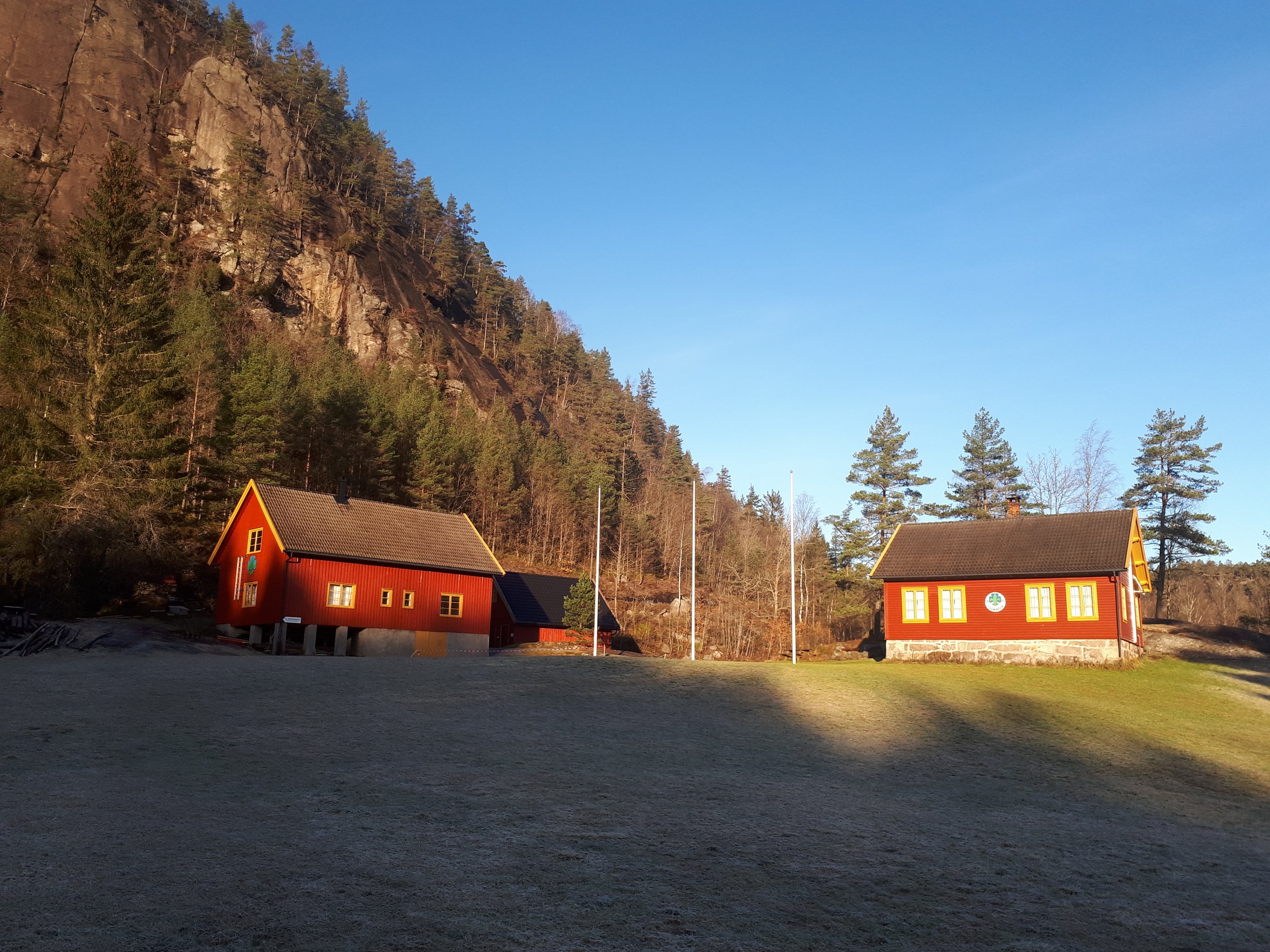
About 1 1/2km up Tømmerrenna you can exit on the left and follow a short trail to Paulen. Paulen is an old farm that was inhabited until 1962. Today it is owned by 1. Vennesla scout group, and they use it as a campground for scout camps and lots of other activities. Some Sundays they even have a little kiosk open in the old stable in the barn, where they sell waffles and coffee. Here you can find a few fire pits, a small obstacle course, three lean-tos, as well as the old farmhouse and barn, and a garage of a newer date.[5] The firepits are open to the public, just make sure to bring your own firewood if you plan on using them. This is a super place to bring kids as the hike in is not too long and the area has lots of space to play. It is also possible to rent the house, barn, and lean-tos if you would like to spend the night.[6]


Slottet
If you stop by Paulen but want to go for a longer walk you can continue across the field to the train platform. About 50m north of the platform there is a trail that takes you to Slottet. Slottet was a husmannsplass (the closest translation I could find in English would be a Croft, although the husmanns system was not exactly the same thing) under the farm Paulen. Today there is not much left, but you can still see the foundations of some of the buildings. Be careful when crossing the train tracks as there may be trains even on days when there are no museum trains schedules. The trail up to Slottet is usually quite wet, so proper boots are recommended. The hike from Paulen to Slottet is ca. 700 m and it is uphill all the way so here you can get yourself some good condition training.


Paulefjellet
If the hill up to Slottet hasn’t taken everything out of you I would recommend continuing on the trail to the right to the top of Paulefjellet. Follow the trail for about 900m, here the forest should be a bit more open and there is a trail that goes down on the right towards the edge of the mountain. The trail down to the viewpoint can be a bit hard to find, but if you find it the view down towards Paulen is quite spectacular.

Kringsjå
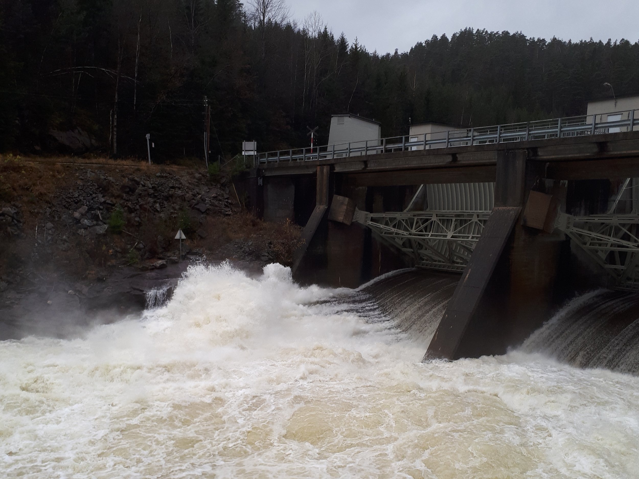
If you continue a little bit past the exit to Paulen you will reach an old stone dam. Tømmerrenna continues through the dam, but if you walk up onto the dam you can follow it around until you reach Paulefossen. This was the first waterfall the Norwegian state purchased the rights to in 1895.[7] The purpose of this was to be able to provide power to operate Setesdalsbanen.[8] The state never ended up using their rights to the waterfall, but the purchase is still considered to mark the start of Statkraft.[9] Follow the trail from the dam and over the bridge to the other side of the river, remember to stop and take a look at the waterfall from the bridge. The waterfall can be a bit underwhelming if the waterflow in the river is low but what you get in return is a look at the beautifull wall behind the waterfall. Continue following the trail until you reach a crossing gravel road. Turn right onto the gravel road and follow it to the top of the small hill. From here you can see the ruins of Kringsjå hydropower plant. Kringsjå powerplant was constructed around 1900 by Kristiansands Fossefald og Elektricitetsverk and was in operation until 1957.[10] Around the powerplant a small community was built with houses for the workers and even a school. Sometime after the powerplant closed down all the buildings in the area were demolished, and today only the foundations of the buildings are left. There are some information signs near the ruins of the powerplant, as well as signs around the area with pictures of some of the buildings that once stood there. When you want to head back you can either go back to Tømmerrenna or you can follow the gravel road until you reach the road from Beihølen to Kvernhusdalen and then follow this back to where you started form.


Knudane
Not to far from Balkongen there is another exit on the right side of the log flume. If you exit here, you can follow a short trail up to a gravel road. If you turn left onto this road and follow it for 200m you will reach an interesting cluster of wood “buildings”. You will probably not find anything like this anywhere ales, so these are well worth taking a look at. If you continue following the road for 700m past these and up a steep hill you will reach Knudane. There has likely been some sort of farm at Knudane since 1647[11], and today the foundations of a few larger buildings can be seen at the site. From here you can follow the road back down to where you came up from Tømmerrenna. In stead of going back down Tømmerrenna you can continue on the gravel road until you reach Kringsjå. From here you can sircle back to Tømmerrenna or you can continue following the road until you reach Kvernhusdalen as described in previous sections.


I hope you found something of interest here, and that you might try exploring a little more of the area surrounding Tømmerenna the next time you visit.
Sources:
[1] https://grub.no/attraksjon/tommerrenna/
[2] https://grub.no/attraksjon/tommerrenna/
[3] https://www.vestagdermuseet.no/setesdalsbanen/
[4] https://www.nb.no/nbsok/nb/269510bec67d020b9f1d13acce63edac?index=1#80 p. 80-81
[5] http://www.1vennesla.no/?page_id=1254
[6] http://www.1vennesla.no/?page_id=1254
[7] https://www.statkraft.com/about-statkraft/our-history/#1895-1945
[8] https://www.statkraft.com/about-statkraft/our-history/#1895-1945/1895
[9] https://www.statkraft.com/about-statkraft/our-history/#1895-1945/1895
[10] https://www.nve.no/om-nve/nves-utvalgte-kulturminner/dammer/kringsja/
[11] https://www.geocaching.com/geocache/GC5ZMJC_knutane?guid=7b3589e3-c598-4c40-a478-72ec6856a91a